
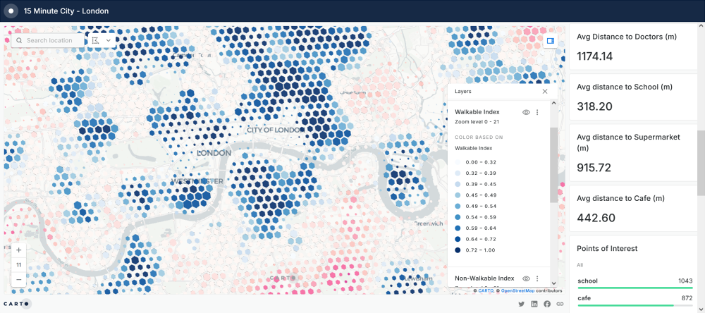
GIS technology plays a crucial role in analyzing spatial data and supporting evidence-based decision-making. GIS professionals use geographic data to solve real-world problems in fields such as urban planning, environmental management, transportation, and public health.
The ability to visualize and interpret spatial relationships has become invaluable, particularly as we deal with challenges like climate change, resource allocation, and infrastructure development. By acquiring GIS skills, you’ll be equipped to contribute to important initiatives that shape our future.
A GIS certification opens doors to a variety of career paths across multiple industries. Here are just a few examples:
- Urban and Regional Planning: GIS professionals help cities and towns plan for sustainable growth, manage land use, and design transportation networks.
- Environmental Science: GIS is crucial for managing natural resources, tracking wildlife, and assessing environmental impact.
- Public Health: GIS is used to map disease outbreaks, optimize healthcare resource allocation, and analyze environmental health risks.
- Transportation and Logistics: GIS plays a key role in route planning, supply chain management, and infrastructure maintenance.
- Disaster Management: GIS professionals are involved in emergency response planning, flood modeling, and damage assessment post-disasters.
Whether you’re looking to enhance your current skill set or transition into a new career, our GIS Certificate Program provides the expertise you need to succeed in this growing field.
For more examples of GIS, you can learn about some of the GeoPlan Center’s own projects, including the Florida Geographic Data Library and Sea Level Scenario Sketch Planning Tool, which both include public web maps. You can also browse the Projects, Past Projects and Student Showcase pages.